News

8 New Maps Published in the Weiser area!

DWM-194 Geologic Map of the Paddock Valley Reservoir Quadrangle, Payette and Washington Counties, Idaho
DWM-194

DWM-195 Geologic Map of the Sheep Ridge Quadrangle, Payette County, Idaho
DWM-195

DWM-196 Geologic Map of the Hog Cove Butte Quadrangle, Gem and Payette Counties, Idaho
DWM-196

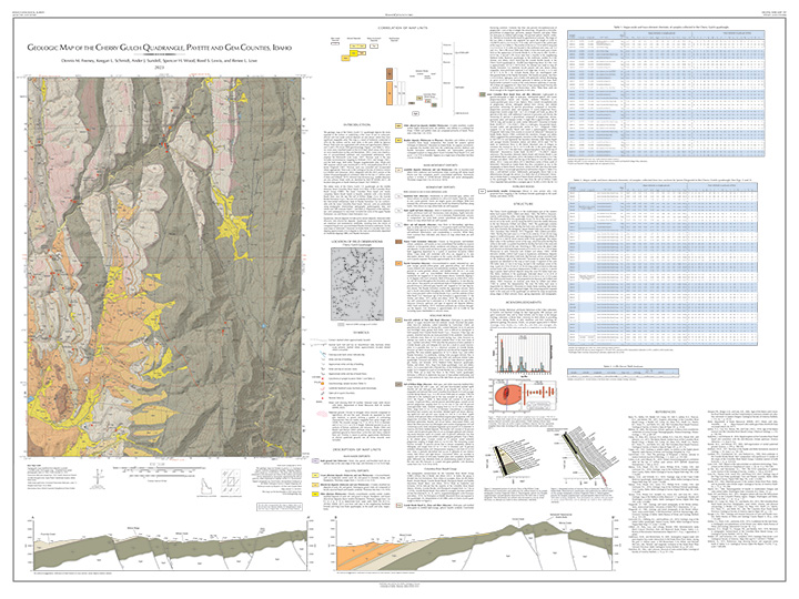
DWM-197 Geologic Map of the Cherry Gulch Quadrangle, Payette and Gem Counties, Idaho
DWM-197

DWM-214 Geologic Map of the Weiser South Quadrangle, Payette and Washington Counties, Idaho and Malheur County, Oregon
DWM-214

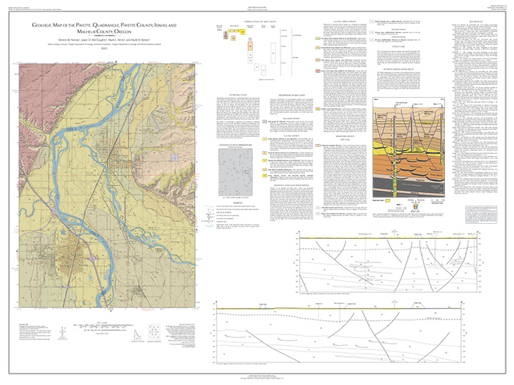
DWM-215 Geologic Map of the Payette Quadrangle, Payette County, Idaho, and Malheur County, Oregon
DWM-215

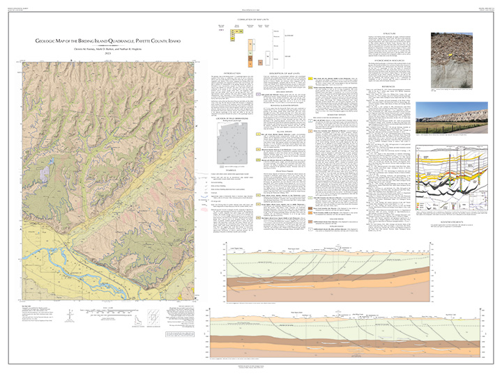
DWM-216 Geologic Map of the Birding Island Quadrangle, Payette County, Idaho
DWM-216

DWM-218 Geologic Map of the Mann Creek Northwest Quadrangle, Washington County, Idaho
DWM-218

IGS is hiring a Geologic Mapping Lab Manager!

Join Our Team

IGS is accepting applications for a motivated and enthusiastic Geoscience Manager to join our team and lead and manage the Geologic Mapping Lab.
View a comprehensive list of job duties and responsibilities and then apply for the job through the University of Idaho Careers Page.

6 New Digital Web Maps Published!

DWM-208 Geologic Map of the Lake Mountain Quadrangle, Lemhi County, Idaho
DWM-208

DWM-209 Geologic Map of the Center Star Mountain Quadrangle, Idaho County, Idaho
DWM-209

DWM-210 Geologic Map of the Blackbird Creek Quadrangle, Lemhi County, Idaho
DWM-210

DWM-211 Geologic Map of the Opal Lake Quadrangle, Lemhi County, Idaho
DWM-211

DWM-212 Geologic Map of the Napoleon Hill Quadrangle, Lemhi County, Idaho
DWM-212

DWM-213 Geologic Map of the Pine Creek Ridge Quadrangle, Lemhi County, Idaho
DWM-213

Just Released: Magnetic susceptibility data for Idaho