More than 3,200 aftershocks have been recorded in
the year following the 3/31/2020 M6.5 Stanley Earthquake. This animation shows
just how active the area has been.
If you have field data, maps, figures, or other
observations to contribute to the virtual clearinghouse, please contact Zach
Lifton: zlifton@uidaho.edu.

No
injuries and only minor damage were
reported:
- Lemhi County residents reported some damage to
windows and pictures falling off walls. Critical infrastructure, such as the
courthouse, post office, and some propane lines, was inspected for structural
damage.
- ITD did not report any major issues. There were
several rock slides on Highway 21, but crews cleared them within a few days of
the earthquake. ITD crews examined bridges and roads in districts 3, 4, 5, and
6.
- Boise County did not report any major damage and
all roads remained open. Initial assessments of historic brick and mortar
buildings in Idaho City showed very minor damage. Initial assessment of other
critical infrastructure showed no damage. The Sheriff's office sustained some
minor damage. Some residents reported broken windows.
- No major damage reported in the town of
Stanley or Custer County.
Interactive Webmap
This map shows basic geologic data related to the
earthquake, such as bedrock mapping, faults, aerial reconnaissance information,
and earthquake epicenters. A static layer of seismicity from 3/31/2020 (the day
of the M6.5 mainshock earthquake) through 3/26/2021 is shown by default. This
layer will be updated periodically. You can also turn on a live feed of
seismicity from the USGS catalog. Note that the earthquake feed epicenters are
updated automatically and this layer displays earthquakes <M4.5 from the
past 7 days, and earthquakes <M3.0 from the past 3 days. Search the complete catalog
here.
Open the side panel (box in upper left with arrows)
to see legend and turn layers on/off.
View larger map
Whose Fault?
The earthquake mechanism is not as straightforward
as one would expect. Simple extensional motion on the Sawtooth normal fault
seems like the most obvious mechanism, however the focal mechanism is more
complicated and suggests complex strike-slip motion. Below left is the focal
mechanism from USGS, showing a partially non-double couple solution. Below
right is a more recent focal mechanism from Jamie Farrell and Katherine Whidden
at University of Utah Seismograph Stations
that is nearly a pure double couple.
Geologists and seismologists are still collecting
data to determine which fault caused this earthquake. The Sawtooth fault, a
normal fault which runs along the east side of the Sawtooth Mountain range, is
the largest and best known fault in the region. However, the Sawtooth fault is
still not well understood. We only have a general idea of the long-term slip
rate and the timing of past earthquakes (e.g., Thackray et al., 2013).
The M6.5 earthquake was located just north of the
mapped trace of the Sawtooth fault, and the subsequent aftershocks outline an
approximately north-south trend extending off the north end of the Sawtooth
fault. Because aftershocks often occur along the same fault as the mainshock,
they can provide information about the fault structure (e.g., location, dip,
depth). In this case, the aftershocks have occurred west and south of the
mainshock. Aftershocks have defined a relatively linear pattern suggesting a
fault oriented north-northwest. This fits one of the fault planes described by
the focal mechanisms, and suggests the fault motion is left-lateral
strike-slip. The preferred fault plane, at least used by USGS in their finite fault modelling, is a N-S
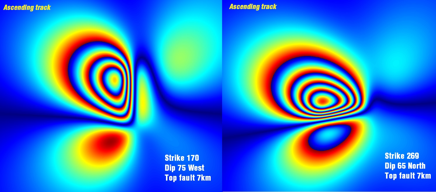
striking fault with left-lateral motion. Initial InSAR interferograms of the epicentral
region show a distinct deformation pattern that seems to fit a N-S striking
fault. The examples below were created by Sotiris Valkaniotis
(@SotisValkan).
This is somewhat unusual because the Sawtooth fault
is believed to be a typical Basin and Range-style normal fault. Left-lateral
motion on a N-S striking fault is not easily explained by the regional stress
field. Furthermore, there is no mapped fault or clear surface topographic
expression of a fault along the trend of aftershocks. Earthquakes like this may
illustrate the complexity of fault tips (e.g., Bruno et al., 2017), and scarcity of detailed
mapping and paleoseismic data in Idaho.
The aftershocks have also defined a linear east-west
oriented pattern of seismicity, extending east from and perpendicular to the
primary north-northwest pattern. It is still not clear if these patterns are
defining previously active faults, or how these structures are interacting with
the Sawtooth fault.
Further analysis of aftershocks (see Seismic
Monitoring below) will help resolve the orientation and geometry of the fault
plane.
Field
Reconnaissance
Conducting
field reconnaissance as soon after an earthquake is important for collecting
perishable data. According to Marie Peppler, USGS (email communication
3/31/20),
“In
the immediate time following a natural disaster, like an earthquake, access to
damaged areas to collect perishable data is critical to assessing risk for
first responders, defining the hazards clearly and providing information that
informs models and future response and mitigation activities. The data will not
last long (i.e. landslides are cleaned off of roads, buildings are repaired) so
it needs to be collected immediately following the
event.”
However,
several factors made immediate field reconnaissance difficult following the
Stanley earthquake:
- The
earthquake occurred in a remote
location
- There
was significant late season snow in the area (~27 inches near Cape Horn in the
days before the earthquake).
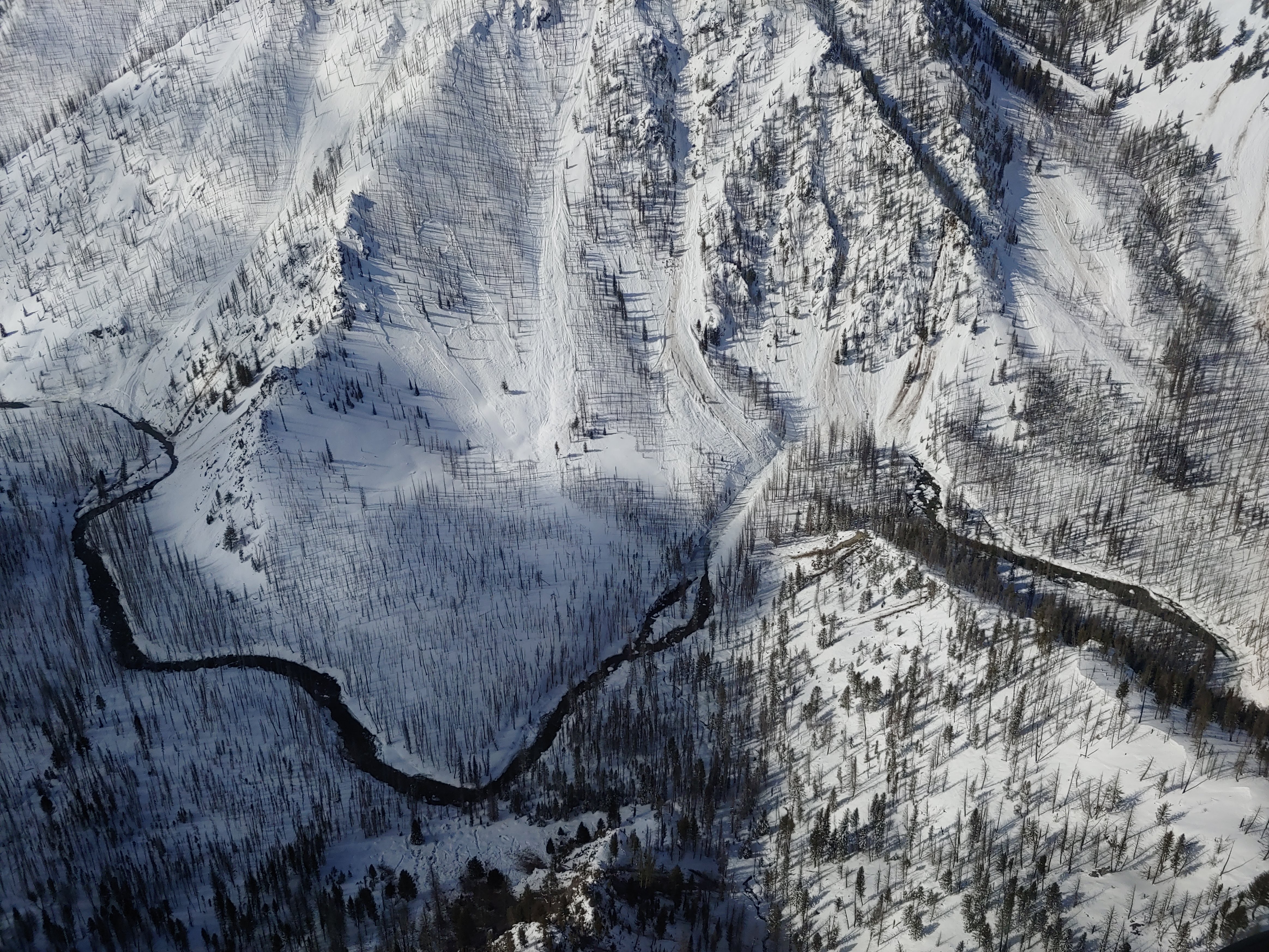
- The
main highway in the area, Highway 21, was closed just west of the epicenter.
ITD closed the road a few hours before the earthquake occurred because the
avalanche danger was high. Several snow avalanches and rockfall blocked the
highway (see photos below).
- Idaho
was under a statewide stay-at-home order because of the coronavirus pandemic.
The route to Stanley passes through Ketchum. Both communities were hard hit by
COVID-19 cases and/or inundation with travelers seeking shelter in remote
locations.

On Thursday, April 2, IGS Director and State
Geologist Claudio Berti and IGS Hazards Geologist Zach Lifton conducted an
overflight of the earthquake epicenter region to make observations of possible
earthquake effects. A second overflight took place on April 9, 2020. During
both flights, there was significant snow cover across the area. We observed
many small snow avalanches, including some that blocked Highway 21 and some
small streams. Minor rockfall occurred on steep slopes, but was not very
extensive. One large boulder rolled down onto Highway 21. We
didn't observe any obvious ground rupture of the fault. It may
have been obscured by snow, but the ground looked undisturbed and intact.
Perhaps subtle ground rupture or deformation will be visible when the snow
melts.
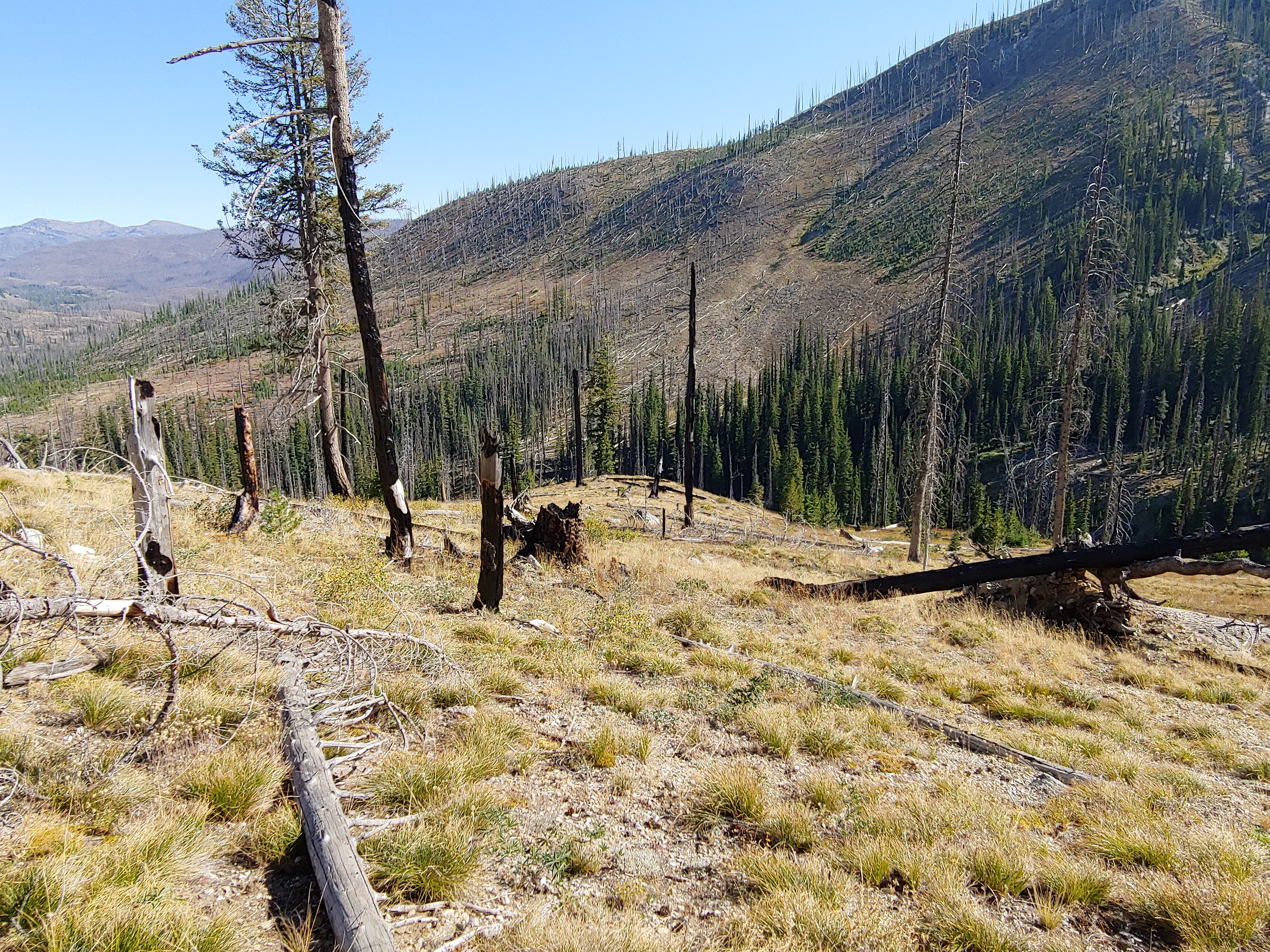
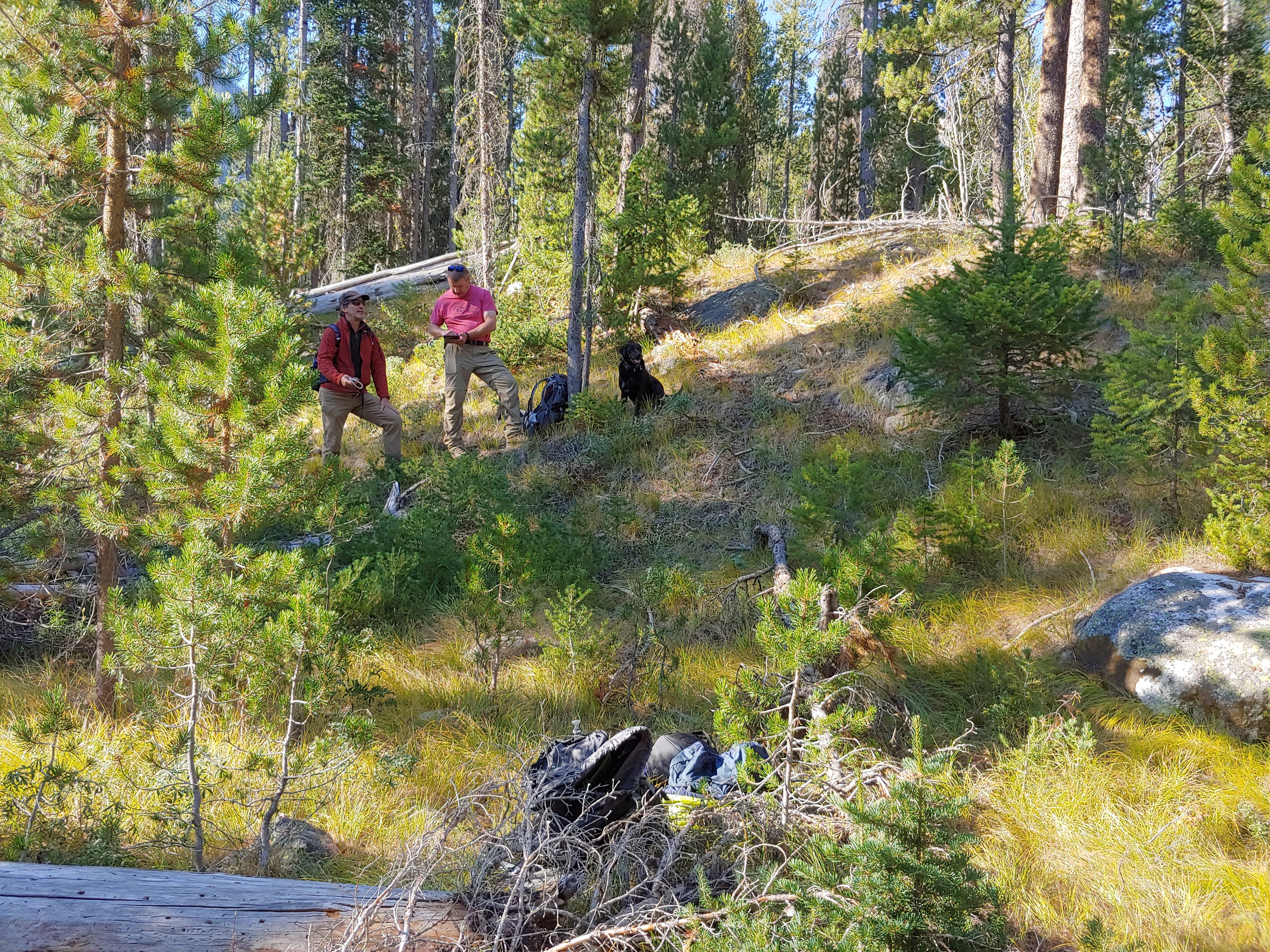
Geologists from IGS, Idaho State University, and
the U.S. Geological Survey conducted ground reconnaissance of the epicentral
area and the Sawtooth fault in September 2020 to make observations of possible
earthquake effects. We did not observe any surface fault rupture
or ground deformation related to the Stanley earthquake.
Seismic Monitoring
Aftershocks continue to occur one year after the
M6.5 mainshock. At least 19 aftershocks greater than M4 have been recorded,
including a M4.8. More than 3,200 aftershocks related to this event have been
recorded in the USGS earthquake catalog.
USGS has created an aftershock forecast. Note that these are
NOT predictions. Aftershock forecasts are based on statistics of other observed
earthquakes.
Seismic monitoring is a critical component of
earthquake response. With the sparse distribution of existing permanent
seismometers in central Idaho, it is important to deploy additional temporary
instruments to record the aftershock sequence. And since the number of
aftershocks decays over time, instruments need to be deployed immediately.
Instrument deployment and monitoring is being led by a team from Boise State University, including
Professors Lee Liberty, Dylan Mikesell, and Jeffrey Johnson. They have
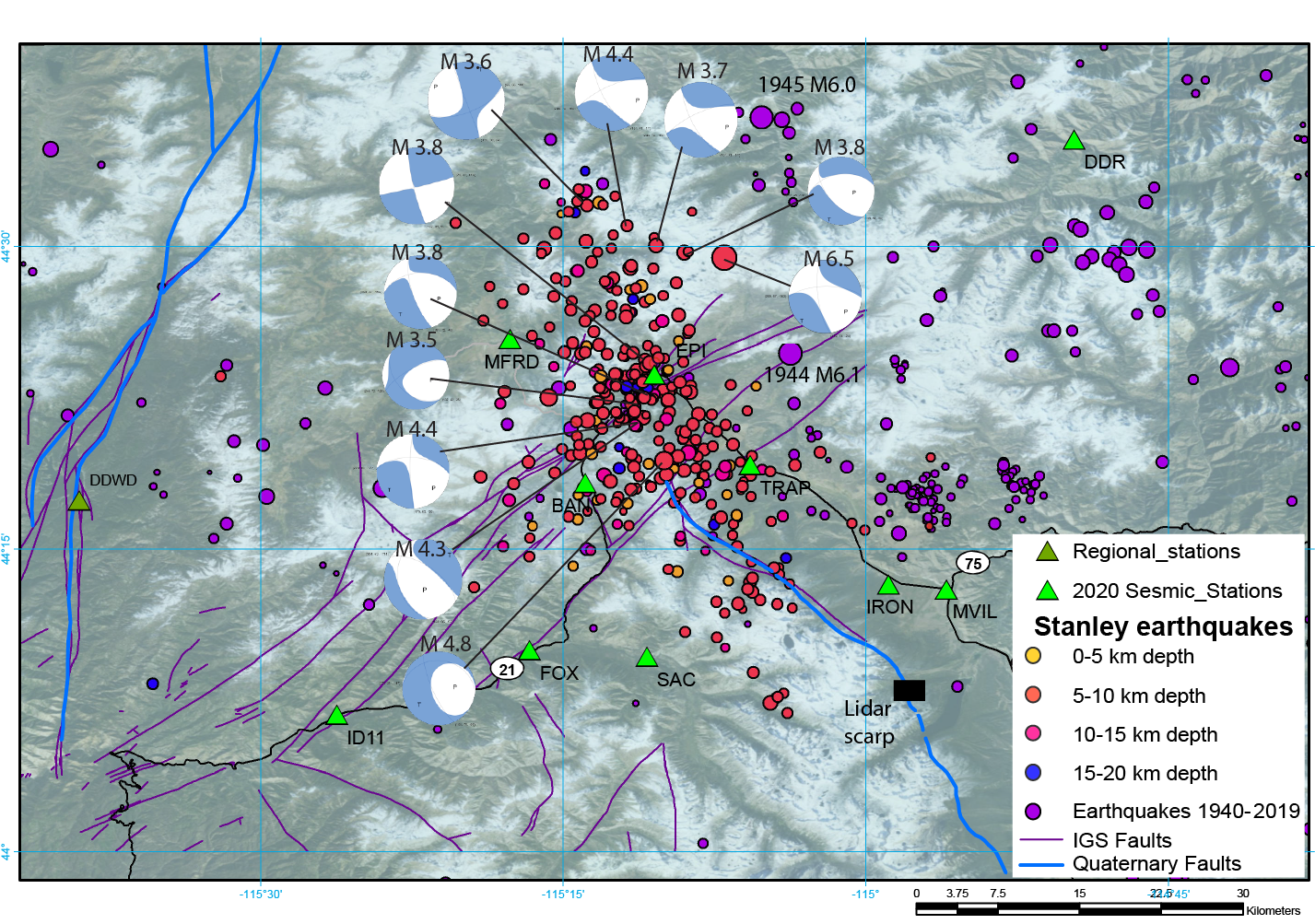
installed 14 seismometers near the epicenter. The map below by Lee Liberty shows
the location of the BSU and IGS/PASSCAL instruments, as well as earthquake
epicenters, focal mechanisms, and historical seismicity. In addition, 24 nodal
sensors (wireless geophones), and more seismometers borrowed from IRIS are
being deployed.
IGS Director Claudio Berti, IGS Hazards Geologist
Zach Lifton, and BSU Research Assistant Thomas Otheim installed two temporary
seismometers at Diamond D Ranch and Middle Fork Lodge, both along the Middle
Fork Salmon River. Data from these and other non-telemetered stations will be downloaded
regularly.
Changes at the Stanley Lake Inlet Delta
On May 7th, colleagues from the US Forest Service
reported that the inlet delta of Stanley Lake, a popular beach and recreational
site, was now under many feet of water. Pictures from the field and reports of
field observation suggest that the "disappearance" of the delta is a
combination of liquefaction/compaction of saturated sediments and lateral
spreading of the delta into the deeper part of the lake. IGS geologists visited
Stanley Lake in May 2020 to record observations of the liquefaction
event.
Visit the Stanley Lake Liquefaction page for more
details.
Connection
to
Yellowstone?
We
have received questions from the public about whether this earthquake could be
related to the Yellowstone volcanic field. The answer is
“No”. The Stanley earthquake is over 200 miles away from
Yellowstone and located in a very different tectonic environment. Basin and
Range extension is driving tectonic activity in central Idaho, there is no
current volcanic activity in the area. Mike Poland, USGS Yellowstone Volcano
Observatory scientist-in-charge,
said:
“It’s
been an eventful month for seismic activity in the western USA, with a M5.7
earthquake near Salt Lake City, Utah, on March 18, and a M6.5 in central Idaho
on March 31. These earthquakes are caused by tectonic extension of the region
and are not related to Yellowstone, nor will they have a significant impact on
the Yellowstone system. Some strong earthquakes in the region, like the 1983
M6.9 Borah Peak, ID, and 1959 M7.3 Hebgen Lake, MT, earthquakes, have impacted
geyser behavior, but that is due to the response of the shallow and fragile
geyser conduits to shaking. It is not yet clear if the M6.5 in central Idaho
will have a similar impact; observations of geyser activity over the coming
days to weeks will answer that
question.”
More from Yellowstone Volcano Observatory on the
recent seismicity in the western U.S.
Follow the latest news on Twitter: