Idaho's Ground Water
The Idaho Geological Survey is the lead agency for collecting and disseminating geologic information and mineral data in the state. It has offices in Moscow, Boise, and Pocatello. Staff geologists conduct applied research with a strong emphasis on producing geologic maps and providing technical and general information on the State's various geologic settings, earth resources, and geologic hazards. Much of the research is conducted through cooperative programs with other agencies and applies to the growing development and use of land and water in Idaho.
Primacy over managing and regulating the state's water rights and water quality lies with the Idaho Departments of Water Resources and Environmental Quality, respectively. The Idaho Geological Survey, a non-regulatory agency, works closely with these and other state agencies, providing unbiased technical assistance, conducting applied hydrogeologic research, and mapping the geologic and hydrogeologic characteristics that are critical to informed water-resource decisions.
Ground Water
Idaho's ground water is one of the state's most valuable natural resources. If water were so classified, it would be Idaho's most valuable mineral resource. Ground water accounts for over 20% of Idaho's 20 billion gallons of daily water usage and for over 92% of the state's drinking water supply. Over six trillion gallons of water are applied annually to almost four million irrigated acres of land, supporting a $5.3 billion agricultural economy. Half of this acreage is irrigated by ground water which represents only one fifth of all agricultural water usage, a fact that reflects the greater efficiency of sprinkler-based irrigation over flood irrigation methods.
Hydrogeology
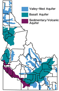 The aquifers that host the state's ground-water reservoirs represent a wide range of geologic materials, structures, and mineral compositions. For example, the aquifers of Idaho's intermountain valleys that represent such a vital local water resource for communities, ranchers and farmers are hosted in silty sands and gravels; such ground water tends to be quite hard because of the dissolution of these aquifer materials. In contrast, Idaho's largest aquifer, hosted in fractured basaltic lava beneath the eastern Snake River Plain, tends to have lower hardness and dissolved mineral contents because of its unique mineralogy and very high ground water flow rate.
Geologic differences also influence an aquifer's susceptibility to contamination. For example, the eastern Snake River Plain aquifer is more vulnerable to being contaminated from surface activities such as septic sewage disposal, over-fertilization, and chemical spillsthan its tributary valley aquifers; it also spreads contamination faster once it becomes contaminated, because its ground water moves through fractures, rubble zones and lava tubes within and between the lava flows that comprise the aquifer. In contrast, the water moving through pore spaces between the grains of a silt/gravel aquifer generally experiences more efficient contaminant filtering and trapping.
Applications of Hydrogeologic Research
Historically, the Idaho Geological Survey's mission has focused on the mapping of bedrock and sedimentary materials exposed at the surface, together with their physical, chemical, and geological relationships, in order to understand the geologic history and structure of the landscape. Under the STATEMAP mapping program, these fundamental goals are gradually being refined and augmented as more subsurface information is incorporated from drillers' logs, geophysical soundings, and the hydrologic relationships between the geologic materials and the aquifers they host. The integration of surface and subsurface information to map such parameters as depth to bedrock, thickness of sand and gravel, and depth to ground water promises to provide more data that is directly relevant in the decision-making process of urban and county planners, engineers and developers, and geotechnical investigators.
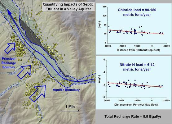
Aside from geologic mapping, the Idaho Geological Survey is actively engaged in applied hydrogeologic research that supports and complements other state agencies' ability to manage Idaho’s ground water. For example, the Idaho Geological Survey has conducted detailed studies of the impact of septic sewage disposal on ground-water quality, to predict the impact of septic-based development and to provide basic information for planning and decision-making purposes. Probabilistic aquifer modeling techniques have been applied to the complex geologic architecture of the basalt aquifer beneath the Department of Energy's Idaho National Laboratory, to provide better estimates of the prediction uncertainties associated with contaminant movement in this complex aquifer. Similar methods have been applied to analyze ground water quality data from the state's monitoring network, to delineate areas of degraded ground water quality, and to develop spatial-temporal analysis methods to map statistically-significant trends in ground-water quality.
In addition to its many research and service activities, the Idaho Geological Survey is also deeply committed to education and outreach activities throughout the state, in order to promote the awareness and understanding of Idaho's geologic and mineral resources and particularly that unseen but critically important non-mineral resource: ground water.